Coastal Defences
The following review of the development of the coastal protection within the district has been split into convenient sections for ease of explanation.
Shepway Boundary to Dover Harbour
This section of coastline is generally undeveloped and Railtrack is responsible for the maintenance of the defences in this area as they provide protection to the Folkestone to Dover railway, which runs at the foot of the cliffs. They consist primarily of gravity mass concrete sea walls or rock revetment together with extensive works to drain ground water from the slip planes under the Folkestone Warren. In addition the recently constructed defences at Samphire Hoe protect the ventilation equipment for the Channel Tunnel and are maintained by Eurotunnel.
Dover Harbour
Responsibility for this area rests with Dover Harbour Board. Construction of the harbour started in 1847 with the construction of Admiralty Pier and its development continued until 1871. This was extended between 1900 and 1904 by a further 610 metres and at the same time the Eastern Arm and South Breakwater were started with all works completed by 1909. The Prince of Wales Pier was built in 1892 within the harbour.
Dover Harbour to Kingsdown (excluding St Margaret's Bay)
This section consists of chalk cliffs, which are slowly eroding at an average rate of 200mm/year. The erosion is not always gradual and is characterised by occasional sudden large falls. There is little development along the cliff top in these areas and no defensive works have been undertaken, as the rate of erosion is very slow.
St Margaret's Bay
The sea wall at the north end of the bay was originally built privately. One section was refaced in 1972 and further minor repairs carried out to the flanking wall in the late 1970's. The remainder of the sea frontage is protected by a sea wall, which was built in 1950 and, as a result of abrasion damage, partially refaced in 1972. The beach is controlled by 12 groynes, which were originally built of steel rail piles and walings with steel sheet piles and timber planks. Due to severe wear the majority were strengthened in 1982 by concrete plinths encasing worn steel sheet piles and by double planking to protect the steel posts from abrasion. Further maintenance has been undertaken on a routine basis since then.
Kingsdown
 At the south end of the frontage is a recently constructed rock armour wall and substantial concrete defences built by the MOD to defend the former rifle range. In Oldstairs Bay immediately to the north the Council ha completed a scheme in 2001 to construct a rock revetment including 3 timber groynes. Between this wall and the village the beach is retained by a section of timber breastwork 200 metres long and a further three groynes. Until the construction of the defences at Oldstairs Bay the area had suffered from significant erosion over recent years. The material eroded from here has helped to nourish the beach to the north.
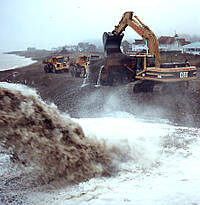
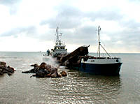
The village is protected by a lightweight concrete panel sea wall, constructed in 1965. By 1978 this wall was being outflanked and overtopped in storms. The wall was therefore extended by 45m southward and 200m northward and a promenade and splash wall were added over the southern 240m. The beach is retained by a total of 15 groynes constructed in 1965 and 1979. A major beach nourishment scheme was carried out in the summer of 1995 involving the importing of 58,000m³ of shingle. Further works were carried out in 1997 to install scour protection at the southern end of the sea wall, and in 1998 further beach nourishment was carried out involving the importation by sea of some 80,000m³ shingle.
Between November 2003 and December 2004 further works were carried out. This involved the following:
- The placing of more rock armour to increase the scour defences carried out in 1997.
- Construction of an 80 metre length of sea wall toe protection linking up with existing at the Southern end
- Reconstruction of a near by storm damaged groyne, plus remedial work to another adjacent groyne was also carried out.
- Beach nourishment along the sea wall and adjacently to the North, incorporated the Importing by sea of 47,000m³ of shingle.
- Construction of a shingle store area, with a peripheral timber fence just North of Kingsdown towards Walmer.
Just prior to the main contract starting, a 48 meter length of esplanade and splash wall became damaged, after part of the sea wall had become undermined after a storm.
Further during the main works a near by boat ramp became damaged after another storm, where the lower half was totally removed leaving only the vertical support members. Although the upper half was still in place, this also suffered damage, but was salvageable.
Therefore as well as the main contract, additional work due to storm damage became included into the main scheme.
Kingsdown to Deal Castle
The sea defences in this area rely primarily on the natural shingle bank. Construction work completed in 1995 has supplemented these natural defences with the construction of a buried timber crib wall extending for 500m parallel to Wellington Parade north of the Kingsdown sea defences to retain the shingle in the event of severe storm. The beach was renourished in 1995 and 1998 as part of the works at Kingsdown.
Deal Castle to Sandown Castle
Construction of the defences at Deal started over 100 years ago. Deal in the 1800's was very different to today as there were no parades or sea walls but only the shingle bank on which brick houses, store houses etc. were built together with a number of wooden jetties. The town was the place of work for hundreds of boatmen who kept up the beach and dealt with denudations after storms. Following storms in 1872 a bank was constructed along the north side of Harold Road to protect the lower part of the town and the sea wall and groynes at the northern end of the frontage were built in 1889. As the character of the town changed the Council acquired from time to time properties on the seaward side of Beach Street and small but separate parades were made with that policy being accelerated between 1920 and 1939 when more properties were bought and the parades linked and extended. Following the 1953 and 1956 storms the defence of the frontage by sea walls was completed by 1960. Groynes are shown to have been constructed between 1938 and 1957 over the northern half with further groynes added between 1958 and 1974.
Following the storm of 1978 further works were undertaken and there are now 32 groynes, of which 27 are of recent construction, to protect the beach. The sea wall along much of this section was reconstructed during the early 1980's and a splash wall added to reduce overtopping. The ruins of Sandown Castle had been destroyed to such an extent that the remaining walls were encased in a concrete sea wall constructed in 1988/89. South of Deal Pier a seawall of unknown form extends as far as Deal Castle and a 200m section of this was refaced during the summer of 1995. Historically the beach has been nourished on several occasions including the importing of 22,000m³ in 1960 and a further 9000m³ in 1974. More recently beach levels have been relatively stable due probably to the volumes of material being driven from Walmer and Kingsdown.
Deal Sea Defence Scheme
Sandown Castle to River Stour (Thanet DC Boundary)
The defence of this low-lying area is the responsibility of the Environment Agency under the various Land Drainage Acts. The defences consist of a shingle bank backed on the southern section by a rock mound revetment.
Contact
Email: propertyservices@dover.gov.uk