Our Coastal Environment
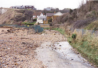
At Deal the residential area dominates the frontage with commercial, tourist and recreation facilities also present. Steep chalk cliffs commence at Kingsdown where the disused Ministry of Defence defences of the former Royal Marines Rifle Range lie at the base.
Extensive nature conservation designations cover the remaining coastline with the characteristic white cliffs classified as Heritage Coast. Sites of Special Scientific Interest (SSSI) nature conservation designations cover large sections of the coastline to the south of Kingsdown. An Area of Outstanding Natural Beauty (AONB) south of Oldstairs Bay extends approximately one kilometre offshore and three kilometres inland.
The sections of the frontage for which Dover District Council is responsible are predominantly of shingle bank form. A narrow strip of flint shingle first appears at the foot of the cliffs near Hope Point and widens and thickens as it continues northwards. Historically, material had derived from the erosion of the chalk cliffs and also from offshore sources. However, there is currently no significant source of shingle known offshore and only a small quantity is derived from the cliffs.
Contact
Email: propertyservices@dover.gov.uk