Better Planning Applications
This guide will help everyone who is involved in making planning applications, particularly for those wishing to extend an existing dwelling, or build one or two houses. Additionally it will be of use for developers of housing estates or commercial property. Obviously the level of detail required will vary accordingly, but the fundamental principles will remain the same.
The guidance will be particularly relevant to applications within historic towns, conservation areas, or sites close to listed buildings, however it can be applied anywhere.
In order to give yourself the best possible chance of gaining planning permission, it is essential that you present your proposals fully, clearly and accurately. Failure to do so will result in your scheme being delayed to await further information or being refused, which could cost you time and money.
Unless you have the training or experience in architectural design and a clear understanding of building construction, it is advisable to employ the services of a qualified architect, surveyor or planning consultant to act on your behalf as your agent.
Giving your application the best chance of success involves more than filling out a form and submitting a few drawings. The following steps should help you, or your agent, avoid common mistakes and omissions, which can result in the delay or misunderstanding of your application.
Step 1 - Carry out your own research
The work carried out before a formal application is made is invaluable. Try to find out the following before you contact a planning officer:
- Relevant policies covering your site in the local development plan, including any constraints, such as risk of flooding.
- Planning history in terms of previous planning applications or appeals.
- Advice in the form of Government Planning Policy Guidance or Statement (PPG or PPS) notes or local supplementary planning guidance (SPG).
- Relevant leaflets or guidance notes, such as planning briefs.
- If the site is in a conservation area, has a Character Appraisal been published?
- Is your building 'Listed' as being of special architectural or historic interest?
Answers to all these topics should be available at the reception desk of your local planning department. Some of the information may also be available on your local authority's web site.
Early consultation with the Planning Authority is advisable if possible.
Step 2 - Seek informal advice from the planning officer before submitting an application
Assess all the available information and consider whether your scheme is feasible. If you consider it is, then the next step is to contact the planning officer who covers the area where your site is located. You can then discuss your project informally, before working up the proposals in detail. (Please note that not all local authorities have the resources to provide this service.)
Early dialogue will help to identify any special constraints, such as highway issues, which were not revealed in your initial research. These issues and any policy constraints may influence the viability of your scheme.
These discussions can also establish the type of supporting information that will help the council and other groups to assess the application. A site and setting analysis and design statement should be considered for all sites, but will be particularly important for sites in conservation areas or close to Listed Buildings.
. It would be useful to discuss your outline proposals with your neighbours.
Step 3 Prepare a site and setting analysis
Although the level of detail will vary, a site and setting analysis is just as important for a small infill site as it is for a large development. This should include a factual record of the site and the surrounding area and may include annotated maps, drawings and/or photographs. The analysis should include:
- A brief history of the site, with reference to what it has been used for. Refer to any historical plans that may be available. Does the site have any archaeological importance? (This information would be available from the local authority's Sites and Monuments Record)
- The possibility of any land contamination should be noted.
- The size, shape, orientation and topography of the site, including cross sections to show any significant changes in level.
- The location, condition, materials and importance of any existing buildings or structures on the site.
- Existing landscape features such as trees, hedges, ponds, streams, boundary treatments and wildlife habitats.
- Any other features that make the site or area distinctive.
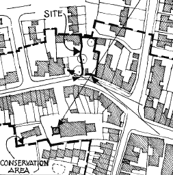
The site in its wider context. Here the site is shown in relation to important views, and the map demonstrates how the curving frontage is an essential part of the street scene. The conservation area boundary is also shown.
- You should note the location of any public utilities both above and below ground, eg power lines, Sewers etc. The Local Authority may be able to provide this information.
- The character of the surrounding area. This should include, for example, land use, landscape, the form, density, height and scale of any development, together with any architectural details such as the design of windows, doors, verges, roof pitches, porches, plinths, chimney stacks and the range of materials used in walls and roofs.
- The road and footpath layout around and adjacent to the site, together with any existing or proposed vehicular/pedestrian access points.
- Important views into and out of the site.
If the site is within a conservation area, much of this information may form part of an existing character appraisal, prepared by the local authority (see Step 1).
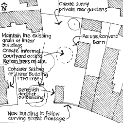
Site Appraisal: highlights aspects that are to be considered in the proposals. This is particularly useful in a design statement.
Step 4 Preparing a design statement
A design statement is a means of structuring and influencing the design process. Current Government advice suggests that a written design statement should set out the design principles, show the proposal in its context and be accompanied by illustrative plans and elevations.
The level of detail will depend on the scale and likely impact of the development, but the process is as important for a small infill site as it is for a major development. Although its complexity will vary, it may include some or all of the following:
- How the proposal responds to the policy background, both national and local.
- The context, including a site and setting analysis, which will highlight any constraints and opportunities for the site.
Much of the work these two aspects will have already been completed under Steps 1 and 3 and could be included as an appendix.
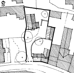
The Site Plan: always show adjacent properties and any access points. This is important to assess impact on neighbouring properties and occupiers.
- The development objectives, eg what the land or buildings will be used for, accommodation requirements, minimum floorspace, number of units etc.
- A summary of the design principles, concepts and options for the site. For example is the intention of the design to reflect local building styles or to contrast with them in some way, whilst maintaining the character of the area.
- Impact on any special features on the site. If it has a negative impact, consider alternative solutions to avoid or reduce this impact.
- An explanation as to how your preferred option responds to the site and surrounding area. You can usefully refer to the site analysis (Step 3), using the same check-list. Note that the aim should not be to simply copy buildings in the area. Good design should respond positively to its context, whilst being both innovative and sustainable. Impact on neighbours, eg: loss of light, overlooking & noise.
- Risk assessments, such as contamination, potential for flooding, pollution, impact on wildlife and archaeological implications. (The redevelopment of certain sites may require specialist advice, for example the redevelopment of a petrol filling station)
- A summary, which will help the planning officer in the preparation of any committee reports.
The way you present your design statement will vary according to the complexity of the site and your proposals. However, as well as including written material, it should be illustrated by:
- Plans and elevations. These should extend beyond the site boundaries in order to show the relationship of the proposals to neighbouring buildings. Even for small sites the adjacent buildings should be shown on plan and elevation. For larger proposals you should show the development within its setting of about 500 metres of the site.
- Photographs of the site and its surroundings.
- Perspective drawings and annotated sketches.
-
If a site is particularly complex then it may be helpful to produce three-dimensional drawings, computers are particularly good for this.
Alternatively an architectural model or a photo montage might be made.
- The planning authority will need to consider the type and colour of materials and possibly the way they are used, especially in conservation areas. This information should be submitted with the planning application.
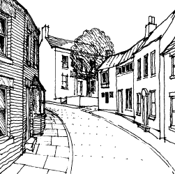
A perspective drawing or computer visualisation of the proposal as seen in the street is crucial to demonstrate its impact.
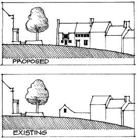
Street elevations, existing and proposed, help to relate the height and scale of the proposal to its neighbours.
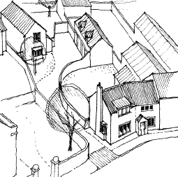
A true to scale axonometric diagram or birds eye view perspective explains the three dimensional relationships between all the buildings and spaces in the site.
Further Information
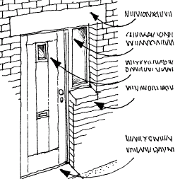 Choice of materials and how they are used will often be crucial aspects of the character of the proposals; these can be explained with detailed drawings.
The Design Statement can be used as a negotiating tool with the planning authority during the development process. It can be amended in the light of discussions and should be submitted in support of your planning application, where it will play an important part in the assessment of your proposal and the decision-making process.
Step 5 Submit your application
After following these steps, you should be ready to submit your application. Time spent in preparation is never wasted. By following this advice, the application should be well presented and considered with the minimum of delay.
Remember that all drawings should be to a metric scale such as 1:20, 1:50, 1:100, 1:200, 1:500 etc and that all plans should display a north point.
Note, the granting of planning permission does not exclude the need to apply for any other consents that may be required, such as Listed Building Consent, Building Regulations, Ancient Monuments Consent etc. Please check what other consents may be required with your local planning authority.
Acknowledgements
Produced by the EHTF Built Environment Working Group, with special thanks to Clive Alexander, Dover District Council, & Richard Guise, University of the West of England, Bristol.
ISBN 1 898261 51 2 Copyright statement - Copyright remains with EHTF October 2003
EHTF P0 Box 22 Bristol BS16 1RZ
Tel: (0117) 975 0459 Fax: (0117) 975 0460
Contact Planning
Telephone: 01304 872486
Email developmentmanagement@dover.gov.uk